
0 محفوظ
ادخل المشهد

The Arabian Peninsula, the late sixth century
Arabia, 570
A caravan crosses the sand at sunset. Below the dunes lie oases, wells and towns, joined by old roads.
اقرأ
Fly over Arabia in 570
Picture yourself above the Arabian Peninsula in the late sixth century. Below you: sand seas, black lava fields, bare mountains along the Red Sea, and here and there a green smudge where water comes to the surface.
The story of the Prophet Muhammad ﷺ, the Seerah (his life story), happens on this map. In this path you will travel it town by town. Start by learning the places, the way you would learn the streets of a new city.
شاهد
Watch: The places you will meet
الطريق
The places you will meet

- Makkah A trading town in a dry, rocky valley around the Ka’bah. He ﷺ was born here.
- Ta’if A cooler hill town of orchards, about 100 km south-east of Makkah.
- Yathrib (Madinah) An oasis of farms and palm groves about 450 km to the north. It later became Madinah.
- Busra in Sham A market town of the Byzantine (Roman) Empire, where Makkan caravans traded.
- Ctesiphon Capital of the Persian (Sasanian) Empire, Rome’s great rival.
- San’a in Yemen The green, rainy south, with old kingdoms and farms on terraced hills.
- Aksum (Abyssinia) A Christian kingdom across the Red Sea, in today’s Ethiopia and Eritrea.
Walk the stops. Makkah sat between two empires and on the road between Yemen and Sham.
انظر
Desert, oasis and town
Think of water the way we think of electricity today: everything depended on it. A well could make a town, and a quarrel over a well could start a war that lasted years.
اعثر عليها
Explore the map
Find the seven places of this story on the blank map.
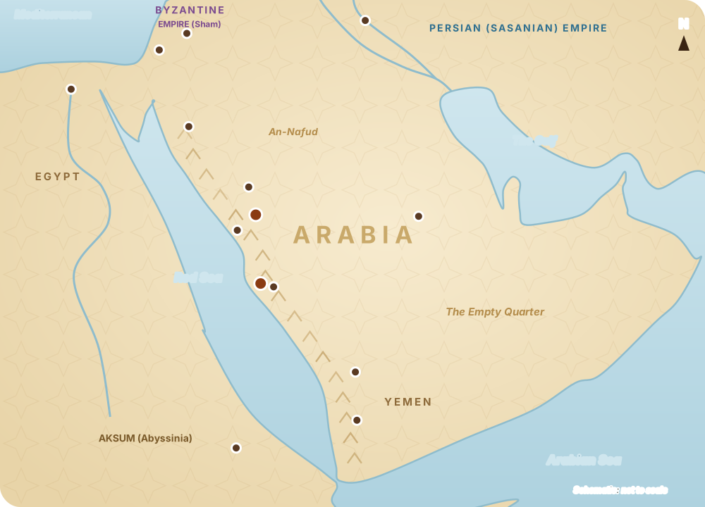
- Makkah A dry valley with the Ka’bah and a trading town around it.
- Ta’if A cool, green town in the mountains to the south-east.
- Yathrib (Madinah) An oasis of palm groves to the north.
- Busra in Sham A market town on the edge of the Byzantine lands.
- Ctesiphon The capital of the Persian Empire, on the Tigris.
- San’a in Yemen The old kingdom of the south.
- Aksum (Abyssinia) A Christian kingdom across the Red Sea.
خمّن
How far to Sham?
About how far was it from Makkah to Busra in Sham by the caravan road?
أظهر الإجابة
1300 km About 1,300 km: a month’s journey by camel, which is why caravans went only twice a year.
المس المكان Find Makkah
Tap Makkah on the map.
أظهر الإجابة
Makkah lies in the west, about 70 km inland from the Red Sea, halfway between Yemen and Sham.
صِل
Match each place
صِل كل واحد بما يناسبه.
- Makkah Trading town around the Ka’bah
- Yathrib Northern oasis of palm groves
- Ta’if Cool hill town with orchards
- Aksum Christian kingdom across the Red Sea
أظهر الإجابة
These four places return again and again in the Seerah: his birthplace, the city he moved to, the town that rejected him, and the kingdom that sheltered his companions.
صح أم خطأ Check
Sixth-century Arabia was an empty desert with no towns.
أظهر الإجابة
It had towns, oases, markets and farms, as well as Bedouin who moved with their herds. Life gathered wherever there was water or trade.
فكّر في الأمر
The people of the desert
People lived well in a land most would call empty, by sharing water, guarding guests and keeping their word. What do you depend on others for, without noticing?
لا يراه أحد غيرك، ويُحفظ على هذا الجهاز.
اقرأ
Water decides everything
In the desert, life follows water. A well or an oasis decided where people settled, which roads caravans took and which tribe was strong.
That is why hospitality mattered so much: today's host might be tomorrow's traveller begging for a drink. Sharing water was not only kindness; it was how everyone stayed alive.
Go deeper: the regions
The Hejaz is the western strip with Makkah, Yathrib (later Madinah) and Ta'if. Najd is the high plateau in the middle. Yemen, in the green south, had old kingdoms and farms. Each region shaped its people differently.
اكشف
Common mistakes
Flip each card: what people often get wrong, and what is right.
- “Arabia was cut off from the world.” It was linked by trade to Sham, Yemen, Iraq and Abyssinia.
- “All Arabs were nomads.” Many lived in towns and oases: Makkah, Yathrib and Ta’if.
- “Makkah was a great city.” It was a modest town, important for the House and for trade. Estimates of its size vary.
اقرأ
A crossroads between empires

Arabia sat between the great powers of the day: Byzantium to the north-west, Persia to the north-east and Abyssinia across the Red Sea. Trade roads ran through it from Yemen to Sham.
So the last message did not begin in a forgotten corner. It began at a crossroads, where news travelled with every caravan.
اقرأ
For your life
The people of the desert survived by sharing what was scarce. We live with plenty, yet many feel alone. The old desert rules still work: offer water, welcome the stranger, keep your word. Small acts of hospitality hold a community together, in a tent or in a city flat.
فكّر في الأمر
A heart moment
A message for the whole world began in a dry valley with no river. Allah does not need grand places to do great things. Which small, ordinary place in your life could hold something great for Him?
لا يراه أحد غيرك، ويُحفظ على هذا الجهاز.
اقرأ
The lesson in three lines
Arabia was dry but full of life, held together by water, honour and trade. It sat between empires, on roads that carried news. Allah chose this crossroads for His final message.
انتهى الدرس
A map of Arabia
أضفت مرحلة من الرحلة إلى رحلة عبر جزيرة العرب.
ما تعلّمته
- Arabia was never empty: deserts, oases and towns, linked by roads between empires.
- منجزة
- 0
- صحيح من أول مرة
- 0
- للمراجعة
- 0
عملك · جرّبه اليوم
Find Makkah, Madinah and Jerusalem on a map, and picture the roads between them.
ما حفظته
سجّل الدخول لتحفظ تقدّمك على كل أجهزتك.